5.17.2009

science and SPACES INTHE NORTHERN ENVIRONMENT

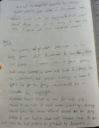
Caribou crossing Alaskan Highway in front of my car - Muncho Lake, British Columbia
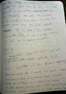
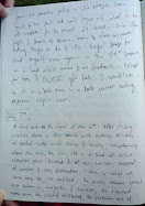
Figure 2. Aerial Surveys of Caribou Populations in 1948

Adapted by Eric Leinberger from A. W. F. Banfield, "The Barren-Ground Caribou," Department of Resources and Development, Northern Administration and Lands Branch, 1951.


THE IMAGE OF NORTHERN scientists, circa 1964, was said to be one of contented indifference to political matters. They were a hardy few, "plying their erudite mysteries among the natives and amid the vastness in virtual aloneness and, to them, happy anonymity."1 But the claim rang false: scientists were neither alone nor anonymous. Accompanied by pilots and administrators, guided by priorities set in southern capitals and universities, scientists had become essential to the political and economic restructuring of northern Canada. 1
Historians have described how scientists have participated in exploiting and sometimes conserving the natural environment. Scholars in other fields have complemented these efforts, charting the complexity of scientists' roles in environmental affairs. Northern Canada offers opportunities to extend this work. The region presents an unusual, sometimes extreme environment—both a challenge and an attraction to scientists; scientists have also historically played a disproportionate role in shaping attitudes and decisions regarding the North. In this article I seek to explain the paths followed by scientists in the North: the topics they studied, the ideas that guided their work, their methods, their influence on decisions, and how these dimensions of scientific work related to the northern environment. My focus will be on two distinct episodes. In the first, extending over several decades but culminating in the early 1950s, northern Canada attracted the attention of ecologists debating the existence and significance of cycles in animal populations. In the second, which took place during the 1960s and 1970s, notions of ecological fragility again drew ecologists to the North, within a political culture newly sensitive to impacts on this environment.

from Stephen Bocking, Science and Spaces in the Northern Environment
Bocking, Stephen, Science and Spaces in the Northern Environment. Environmental History 12.4 (2007): 61 pars. 17 May 2009 .

5.16.2009

arctic terns

purple line is path aerial surveyor took, green line outlines Kendall Island Bird Sanctuary, and size of yellow dot refers to amount of Arctic Terns sited.

The Arctic Tern (Sterna paradisaea) is an Arctic to
Antarctic traveler with annual migrations of up to 24,000
miles round trip. On its wintering grounds, this Olympic
flyer benefits from a “second summer” giving it more
hours of daylight than any other bird.
In addition to excellent flying abilities, this slender
tern is also known for its elegant breeding plumage. The
bill, feet, and legs are blood-red. The upper wings and
back are light gray, contrasting with a jet-black cap. The
tail is long and deeply forked. Arctic Terns often mix on
coastal breeding grounds with Aleutian Terns (Sterna
aleutica). They are similar in appearance and both have a
black cap, but the Aleutian Tern has a white forehead,
black bill, feet and legs, and the wings are a darker gray.
Nests of the Arctic Tern are commonly made near
fresh or salt water in open, usually treeless environments.
The nest is very difficult to spot unless it contains eggs; it
is little more than a shallow depression scraped in the
ground. Intruders in nesting areas are often met with
aggressive dives and pecks on the back or head

cks on the back or head.

more on my website here

5.14.2009

burnt black spruce forest in the boreal corridor of eagle plains

more on fires impact on boreal forest and the mapping that correlates here
http://www.geostrategis.com/p_borealfires.htm
standard mosquito behavior for the Mackenzie Delta

5.13.2009

animated map (still shot) showing proposed roads, pipelines and wells in NWT by 2012

NWT Promotes Pipeline in Texas
By SHAWN BELL, Slave River Journal Reporter 12.MAY.09
The Minister of Industry, Tourism and Investment was in Houston, Texas last week, promoting northern gas and reassuring potential investors that the GNWT still supports the Mackenzie Gas Project. Minister Bob McLeod is especially concerned about the US government’s plans to provide more than the current $18 billion in loan guarantees for an Alaskan pipeline, a situation he says weights the playing field in favour of the Americans. “There’s a new (US) national energy security bill proposed by both Republican and Democrat senators to increase the federal loan guarantee to $30 billion,” McLeod told The Journal. “We feel the federal government should look into this very seriously, should look into raising this issue in Washington.” The primary purpose of McLeod’s Texas trip was to meet with five senior executives from oil and gas companies involved in the Mackenzie Gas Project (MGP). In light of the Joint Review Panel’s delay in a decision on the MGP – the latest indication is that the JRP will release its report in December 2009 – the minister said it is important to let the companies know the GNWT still has the project on its radar. “It’s frustrating for (the companies) too,” McLeod said. “It just points out how much the delay is costing the NWT and Canada.” In a press release, the GNWT stated “the construction and completion of the Mackenzie Gas Project is a pivotal component to realizing the Legislative Assembly’s vision of a prosperous Northwest Territories.” The territory estimates that northern gas reserves could supply US markets with 8 billion cubic-feet of gas per day. When asked why the government would be promoting what is essentially a private industry enterprise, McLeod said the GNWT sees the pipeline as an opportunity to open up the entire Mackenzie basin. “We see it as a basin-opening project,” McLeod said. “If you look at a map, in Alberta they’re drilling 17,000-20,000 wells per year, and that stops right at the NWT border. The only reason it stops there is that oil/gas companies don’t have a way to get the gas south.”

5.07.2009

Mackenzie Gas Project - Environmental Impact Statement

this is an extremely important and exhaustive report.

4.08.2009

The genetic evolution of arctic north america and greenland by ExxonMobil


Stephen Creaney, ExxonMobil Exploration Company (United States)
Michael Sullivan, ExxonMobil Exploration Company (United States)


The sedimentary basins of Arctic North America and Greenland are extremely diverse in their modes of genesis. This controls the development of petroleum systems within these basins as well as their exposure to post-accumulation destructive forces.
The Canadian - Greenland Shield is a significant controlling influence on basin development in the area due to its 60km thick core of well-annealed, highly buoyant continental crust. During the lower Paleozoic platformal sediments accumulated around the flanks of the generally emergent craton with the reduced oxygen atmosphere being conducive to the accumulation of organic rich, oil prone source rocks of Ordovician, Silurian, Devonian and Carboniferous age. The Caledonian suturing at the end of the Paleozoic provided erosional products to the interior forelands and drove hydrocarbon generation in some of these basins.
The Ellesmerian collision in Northern Canada quickly produces the Parry Island foldbelt and segregates the Sverdrup Basin from the Ellesmerian platform. The Caledonian suture attempted to rift open numerous times. These failed rifts were very conducive to the accumulation of source rocks with lacustrine as well as marine (Kimmeridgian) sources being deposited. The rift flank uplift along East Greenland provided a significant sediment source into the Sverdrup Basin. Rifting temporarily propagates into Labrador and opens Baffin Bay with strike slip motion along Nares Strait during the Cretaceous. The movement of the Alpha Ridge "plume" from the high arctic in the Cretaceous into the North Atlantic drives rifting to the east side of Greenland. The North Atlantic opens in the Early Tertiary with abundant associated volcanism and propagates into the arctic with the opening of the Eurasian Basin. Atlantic rifting drives Greenland back into the Sverdrup margin producing the Eurekan Orogeny.
Pacific subduction profoundly affects the western side of the craton generating the Western Cordillera and the Brooks Range. Associated forelands developed and began to be rapidly loaded with Cretaceous - Tertiary sediment. Paleozoic and Mesozoic sources were augmented with Cretaceous sources and significant generation occurred in Northern Alaska and the Western Canada Sedimentary Basin. These basins are characterized by long distance migration, stratigraphic traps and significant basin margin accumulations with a risk for biodegradation. The Cordillera is a very destructive environment for hydrocarbon accumulation with interior collapse basins and transtensional pull-aparts all presenting poor targets for exploration. The final tertiary draining of the North American continent produced the Mackenzie Delta in the Canada Basin which entered an inside corner of the transform rift margin and has been constantly "forced" by ongoing Cordilleran tectonics resulting in some trap rupture.

4.01.2009

Syncrude says duck death toll was 3 times original estimate

Three times as many ducks died in a northern Alberta tailings pond last year than the 500 originally estimated, Syncrude Canada announced Tuesday.

"We can now tell you that the final number is 1,606 birds," Syncrude president and CEO Tom Katinas said

In late April 2008, migrating ducks landed on a tailings pond on Syncrude's Aurora oilsands site.

The company failed to deploy the air cannons it uses to scare the birds away because of severe winter weather. The ducks landed on the open water and sank to the bottom of the lake after they were coated in oil.

3.23.2009

Changes Amplify Arctic Warming


3.16.2009

Budget triples for Mackenzie Valley review panel

SHAWN MCCARTHY AND NATHAN VANDERKLIPPE

From Monday's Globe and Mail

March 16, 2009 at 3:41 AM EDT

OTTAWA and CALGARY — The budget for the panel reviewing the proposed $16-billion Mackenzie Valley Pipeline has nearly tripled amid delays that have frustrated industry and government, an internal federal report says.

The report from the Canadian Environmental Assessment Agency says the Joint Review Panel's costs have risen to $18-million, from the original budget of $6.8-million when it was established in the summer of 2004.

The review panel, headed by chairman Robert Hornal, is charged with assessing the environmental and socioeconomic impacts of the proposed 1,220-kilometre gas pipeline. Last December, the panel announced it would not finish its report in March as planned, but expected to release it at the end of this year.

The federal review of its work found that salaries alone have soared to $11-million, including more than $900,000 for the chairman, said a source who has been briefed on it.

In an interview, Mr. Hornal disputed that figure, saying that he has billed a total of $750,000 through the end of December, 2008. He is not paid a salary, but a standard federal rate of $650 a day for a position like his, he said.

"I don't think I'm overpaid or underpaid," he said. "I'm doing this as a citizen of the country and I'm working hard to do a good job on it."

Other members of the panel are paid $500 a day. Mr. Hornal said the panel itself does not set the budget - that is the responsibility of the federal and territorial agencies that oversee the panel - and the dramatic rise in costs can be attributed to the length of time it has taken to produce a report.

"Primarily, it's taken much longer than we anticipated to do the job," he said.

Stephen Hazell, the executive director of the Sierra Club of Canada and a frequent presenter before the panel, defended the expanded budget.

"It's a lot of money," he said. "But this is a one-time decision that will decide the future of the entire Northwest Territories for decades to come. When you look at it that way, $18-million is probably not that much."

The joint review panel is the first major hurdle that the project's proponents must clear. Its report will form the basis of a regulatory review by the National Energy Board, as well as environmental reviews of local site impacts.

Federal Environment Minister Jim Prentice, Northwest Territories Premier Floyd Roland and the project's proponents have all expressed their frustration with the slow pace of the review panel's deliberations. They also worry that the review panel will fail to meet its December deadline.

Nellie Cournoyea, the chair of the Inuvialuit Regional Corp., called the much-delayed review process, which will span more than five years before it is completed, "insanity."

"This whole process is just mind-boggling," she said. "It was supposed to be everybody sits together, it will be quicker. I don't know how this just ran away somehow."

Mr. Prentice, who also has responsibility for the Northern Pipeline Agency, has offered the consortium of companies a package of financial assistance that includes federal funding for infrastructure and some measure of assuming financial risk in return for a share of the profits.

Critics question whether the pipeline will ever be commercially viable, after technological advancements have reduced the cost of tapping vast amounts of unconventional gas in less remote areas of both the United States and Canada.

The seven-person joint review panel was established in August, 2004, by former Liberal environment minister Stéphane Dion to combine reviews by the federal government, the Northwest Territories and the Inuvialuit Game Council, which has treaty rights to conduct environmental assessments of pipeline projects through land controlled by the Inuvialuit.

The proponents of the Mackenzie Gas Project are Imperial Oil Resources Ventures Limited Partnership, ConocoPhillips Canada (North) Limited, Exxon Mobil Canada Properties, Shell Canada and Mackenzie Valley Aboriginal Pipeline Limited Partnership.

However, TransCanada Pipelines Ltd. has expressed an interest in becoming a partner in the project. TransCanada has already won the right to build the much larger Alaska Highway gas pipeline. Canadian officials have long worried that completion of the Alaska pipeline would make the building of the Mackenzie uneconomic.

3.12.2009

Suncor, contractors face 90 charges over waste water dumping


3.03.2009


map detailing Inuvaliut Settlement Region and subsurface ownership rights.

3.02.2009

Letter to Joint Review Panel

December 23, 2008

Mr. Robert Hornal, Chair
Joint Review Panel for the Mackenzie Gas Project
Suite 302, 125 Mackenzie Road
Inuvik
Northwest Territories
X0E 0T0

Dear Mr. Hornal:

Re: Revised Date for Release of the Joint Review Panel Report
We wish to confirm that the Joint Review Panel Agreement (JRPA or Agreement) parties
have received the December 5th news release issued by the Joint Review Panel (JRP)
regarding the revised December 2009 final report release date. We assume this
announcement by the Panel is a response to the letter from the Mackenzie Valley
Environmental Impact Review Board (MVEIRB) and Inuvialuit Game Council (IGC)
dated November 26th, 2008 requesting that the JRP “determine its best estimate of a
completion date for its final report and relate that information to participants in the
environmental impact review of the Mackenzie Gas Project and the general public…”.
The JRPA requires that any revision to the schedule for the environmental impact review
of the Mackenzie Gas Project be approved by the parties to the Agreement. This letter is
to provide early notice that the revised completion date of December 2009 is not
acceptable to the MVEIRB and the IGC.
The December 2009 completion date came as a major surprise when we had recently
been led to believe that a reasonable expectation would be for the English version of the
Panel’s final report to be available by the end of March 2009 with the final published
report to be available by the end of June 2009.
The revised length of the MGP JRP environmental impact review process is now
significantly longer than that originally set out in the Agreement and the investment of
time and resources has to date been much greater than had been anticipated as being
necessary for this review.
We wish to assure Panel members that the efforts they have expended in responding to
the difficult and complex task they were assigned is appreciated as is their diligence in
meeting that challenge. We are also confident that the Panel will produce a quality final
report.
We therefore consider it important to set out our current expectations of the Panel in
accordance with the Agreement:
Page 1 of 2
1. We suggest that the Panel make every effort to issue its final report in two phases;
a “Decision” document by March 31st, 2009, to be followed by Supplementary
Documents by August 31st, 2009.
The “Decision” document should set out the Panel’s decision, including brief
reasons and identify any mitigation measures recommended by the Panel
regarding the proposed Mackenzie Gas Project. It is not an uncommon practice
for an administrative tribunal to set out a decision and to follow up with more
explanation and detail at a later date. This approach will provide the Panel with a
means of communicating its decision with respect to the proposed project early
without the need to wait for all documents to be produced.
We believe this is a reasonable approach to maintain a schedule that will see the
Panel’s recommended decision and measures released by March 31, 2008 but still
allow the additional time necessary for the Panel to complete the text fully
describing the reasons behind its recommended decision and mitigation measures.
2. We confirm that the parties will be responsible for, and make arrangements for,
all translation and production requirements of both the final “Decision” and
Supplementary Documents through the Northern Gas Project Secretariat, once
these documents are received from the Panel.

The cooperation of the Panel would be appreciated.

Last but not least we want to wish you and the other Panel members all the best of the
season. We look forward to following up on the progress of the Panel early in the New
Year.
Sincerely


Mr. Frank Pokiak, Chair
Inuvialuit Game Council


Mr. Richard Edjericon, Chairperson
Mackenzie Valley Environmental
Impact Review Board


C. Northern Gas Project Secretariat
Page 2 of 2

2.24.2009

Canada's Highway to Hell


Every day approximately 50 new fortune seekers travel north on Canada's Highway 63 to the tar sands of Alberta, to join what may be the world's last great oil rush. The two-lane all-weather highway starts about 100 miles north of the provincial capital, Edmonton, and ends at Fort McMurray, a sprawling city hastily carved out of swampy groves of spruce. The road was originally built in the 1970s to connect a marginal and experimental source of heavy oil with the rest of the country. It has since become a continental artery to a modern-day Klondike that has made Canada the number-one supplier of oil to the United States. That's right -- Canada.

from http://www.onearth.org/article/canadas-highway-to-hell

2.23.2009

Date: Sat, 21 Feb 2009 13:35:22 -0700
Subject: Letter to the Editor
From: tkhalifax@northwestel.net
To: entertainment@nnsl.com; editor@nnsl.com

News North Editor

I just finished reading your article promoting France Benoit’s new “documentary” about the Mackenzie Gas Project and would like to offer the following definition from Oxford:
adjective 1 consisting of documents and other material providing a factual account. 2 using film, photographs, and sound recordings of real events.
While I have not seen this film, from what she’s said in the article gives a pretty good idea of exactly just how “factual” this film really is.
Ms. Benoit and her ilk are under the misconception that by stopping the MGP they will somehow stop production at the “tar” sands. This is an erroneous conclusion that has no basis in fact. The oil sands have done quite well without arctic gas and will continue long into the future without it. Further, there is no science or factual evidence to conclude that there are any negative effects in the downstream waters of the oil sands.
Ms. Benoit must have traveled far and wide to find people to speak out against the pipeline, but if facts matter, most people along the pipeline route are in favour of it.
Yes, Ms. Benoit may receive some attention to her “documentary” in Ottawa, Montreal and even Yellowknife, but we along the proposed pipeline route know the real facts.
The Sierra Club and her other environmental extremist cohorts have decimated the fur industry leaving these communities without an income and without hope. The social and economic impacts of those anti-fur campaigns have ruined a culture and a way of life. The pipeline has shone some glimmer of hope along the valley to these otherwise isolated and poverty-stricken communities.
I invite Ms. Benoit to bring her film to Inuvik. I’ll be standing outside, handing out rotten produce to hurl.

Terry Halifax
867.678.2899
Inuvik

2.22.2009


Sincrude Processing Plant, Fort McMurray, Alberta from louisa conrad on Vimeo.


Washington Post article on Migratory Birds dying in Tar Sands tailing ponds (as shown above, noise your hear is a blast going off to scare birds from landing)
http://www.washingtonpost.com/wp-dyn/content/article/2008/12/25/AR2008122500928.html

CHICAGO -- About half of America's migratory birds fly from destinations as far-flung as Chile to nest in Canada's boreal forest. In Alberta, that forest lies above tar sands that contain oil reserves second only to Saudi Arabia's.

The excavation of the tar sands -- projected to pump $2.4 trillion into Canada's economy between 2010 and 2030 -- could reduce the region's migratory-bird population by almost half, according to a peer-reviewed study released Dec. 2 by U.S. and Canadian environmental groups.

The Connecticut warbler and the blackpoll warbler, which fly through the Washington area en route from Alberta's boreal forests, are among about 300 species affected by tar sands mining. The study estimates that over 30 to 50 years, tar sands excavation will reduce bird populations by anywhere from 6 million to 166 million, including several endangered and threatened species. The world's only natural breeding ground for endangered whooping cranes, for example, lies north of the Albertan tar sands, and the Athabasca River, which feeds the cranes' wetland habitat, flows north through the sands.

Globe special on Tar Sands

info on Beaufort Sea from Arctic Report Card


Canada Basin and Beaufort Gyre

The 2007 Canada Basin and the Beaufort Gyre summer conditions exhibited very strong freshening relative to 2006 and previous years of observations (Richter-Menge et al. 2006). Data collected as part of the Beaufort Gyre Environmental Observatory (BGEO, www.whoi.edu/beaufortgyre/index.html) show that in 2000–07, the total freshwater content in the Beaufort Gyre has not changed dramatically relative to climatology (although the absolute maximum was observed in 2007), but there was a significant change in the freshwater distribution (Fig. O3(c,d)). The center of the freshwater maximum shifted toward Canada and significantly intensified relative to climatology. This region of the Beaufort Gyre is much fresher than 30 yr ago.


http://www.arctic.noaa.gov/reportcard/ocean.html

and some more arctic maps here: http://www.arctic.noaa.gov/maps.html

10.18.2008

Inuvaliut Agrees to Access Agreement

Under Inuvialuit Regional Corporation rules, the Inuvialuit of the community closest to a development - in this case Inuvik - vote on ratifying such agreements.

The Inuvik Community Corporation has a little more than 1,000 members. At the Oct. 1 meeting, 120 people voted in favour of the deals and only seven were opposed.

"It was resounding support of the access and benefits agreements that were negotiated and for the project to proceed," said Duane Smith, chairperson of the Inuvik Community Corporation.

Smith said it was a major endorsement of the project by one of the aboriginal groups along the route.

"If we didn't vote in favour of it, it would be another hindrance to the project proceeding," he said.

The benefits of the agreements cover such things as education, training, employment, scholarships and contracting preference for Inuvialuit businesses in the Inuvialuit settlement region.

Smith said he couldn't get into specifics because the deals are "private agreements."

The multi-billion-dollar Mackenzie Gas Project, which will carry Beaufort Delta natural gas south on a pipeline, is awaiting regulatory approval after which proponents will make a final decision on proceeding.

9.21.2008

unfinished mackenzie delta map

mackenzie confluence
another beginning of mackenzie delta drawing


9.18.2008


gxt seismic work in Beaufort Sea


blue was phase one seismic (3,534km) green is phase two (5,561km) and red is 3d seismic being done in august.fall 2008. the blacks dots are drilled wells

and whitefish from the Beaufort drying in Tuktoyaktuk.


9.17.2008

Midnight Sun Recreation Complex, Inuvik


9.13.2008


the yellow dot is Tuktoyaktuk. the red line is route of the northern passage. the dotted line is the arctic circle.

9.11.2008


and the town of Tuktoyaktuk


9.10.2008


And a view from the ground- on the shores of Tuktoyaktuk, July 6, 2008 looking out at the Beaufort Sea at midnight, 90 degrees, too hot to be in the tent.

Permafrost Map for Northwestern Canada (Mackenzie Region)


Tuktoyaktuk's permafrost made pingo


CONTINUOUS PERMAFROST: 5MH Moderate to high ice content due to presence of ice lenses - Alluvial terrace deposits: silt and silty clay - Colluvial blanket deposits: fine grained diamicton containing some lenses and beds of sand, gravel and rubble - Bedrock area of low resistance to erosion in unglaciated areas 5LH Low to high ice content in sandy sediments, as wedges; moderate to high ice content in silty and clayey sediments, as lenses and rectangular veins; massive ice commonly occurs at depth and in pingos - Lacustrine and marine deposits as plains and intertidal lagoons: interbedded silt, clayey silt, and silty sand, locally underlain by diamicton 5LM Low to moderate ice content, as lenses and reticulate veins, higher ice content with depth; massive ice may be present at base of diamicton and in underlying sediments - Alluvial deposits as fans, plains, and terraces: sands and isolated silty layers - Morainal and colluvial blanket deposits: stony clay diamicton; may overlie marine and glaciofluvial deposits(1,2) - Glaciated upland and piedmont complex: mainly till and disintergrated bedrock; overlies areas of moderate to low slope - Veneered bedrock: diamicton overlying low rounded hills and ridges of unglaciated bedrock - Exposed bedrock: varied bedrock types 5NL Nil to low ice content, as wedges - Alluvial deposits: coarse sand and gravel(3) - Glaciofluvial deposits as outwash plains, kames, and eskers: sand and interbedded sand and gravel(1,4) - Colluvial deposits as blankets and veneers: coarse diamicton; may overlie areas of unglaciated bedrock - Glacially deformed marine deposits: clay and silt, thin beds of fine sand may be present 5N Ice content Nil - Exposed bedrock: varied bedrock types --------------------------------------------------- DISCONTINUOUS PERMAFROST: 4MH Moderate to high ice content where material frozen, as thin seams, reticulate veins, and wedges; massive ice may occur at depth - Lacustrine and glaciolacustrine blanket deposits: primarily silt and silty clay with some fine sand and gravel; thermokarst depression common in areas of high ice content; locally underlain by diamicton(4,5,6) - Alluvial deposits as floodplains and terraces: silty sand and silt; thermokarst depressions common in floodplains(5) 4LM Ice content low to moderate where material frozen, as thin seams, reticulate veins, lenses, and wedges; massive ice may occur at depth - Morainal and colluvial deposits as veneers and blankets: diamicton - Alluvial deposits as floodplains, terraces, and fans: fine grained sand and silt(1) - Glaciofluvial and Glaciolacustrine deposits as outwash plains and plains and terraces: gravel, sand, and silt(1,3,7) - Glaciated upland and piedmont: disintergrated bedrock 4NL Nil to low ice content where material frozen - Glaciofluvial deposits as terraces, eskers, and kames: gravel and sand(3) - Landslide debris deposits: extremely variable textures - Eroded and eroding river banks: surface colluvial materials on moderate to steep valley walls and scarps - Alluvial terrace deposits: gravel(3) 4N Ice content nil where material frozen - Talus aprons: cobbles and boulders - Exposed bedrock: varied bedrock types(8) 4V Highly variable ice content where material frozen, depending on topographic positions: crest of prominent ridges are generally ice-free, intervening depressions have moderate to high ice content - Hummocky, ridged moraine: clayey to gravelly sandy till --------------------------------- INTERMEDIATE: 3MH Moderate to high ice content where material frozen - Lacustrine blanket deposits: silty clay, silt, and sand; locally underlain by diamicton 3LH Low to high ice content where material frozen, as thin seams, lenses, and reticulate veins - Alluvial deposits as fans and terraces: mainly silt and fine sand, locally includes gravel and clay; may be underlain with colluvium - Glaciolacustrine plain deposits: fine sand, silt, and clay 3LM Low to moderate ice content where material frozen, as thin seams, lenses, and wedges - Morainal and colluvial blanket deposits: diamicton - Alluvial deposits as floodplains, fans and aprons, deltas, and terraces, interbedded silt, sand, and gravel(1,3) - Glaciofluvial deposits as outwash plains, fans, and terraces: sand and gravel with veneer of silt or fine grained sand - Marine deposits as tidal flats: interbedded silt, clayey silt, and sand, generally high in organic content 3NL Nil to low ice content where material frozen, as thin seams - Glaciofluvial deposits as outwash plains, kame terraces, and eskers: gravel and sand - Alluvial deposits as deltas, floodplains, terraces: predominantly gravel(3) - Veneered bedrock: poorly sorted diamicton - Eolian deposits: sand 3N Ice content nil where material frozen - Exposed bedrock: varied bedrock types - Talus aprons: cobbles and boulders 3V Variable ice content where material frozen, depending on topographic position: crests of prominent ridges are generally ice free, intervening depressions have moderate to high ice content, as seams and lenses - Hummocky, ridged moraine: clayey to gravelly sandy till --------------------------------- SPORADIC: 2LM Low to moderate ice content where material frozen, as lenses and wedges - Morainal and colluvial blanket deposits: diamicton 2L Low ice content where material frozen 2NL Nil to low ice content where material frozen - Glaciofluvial as outwash plains, drumlins, kames, hummocks, and eskers: sand and interbedded sand and gravel - Veneered bedrock: colluvium - Alluvial deposits and fans, terraces and floodplains: gravel, sand, and silt - Landslide debris deposits: variable textures - Marine beach deposits as spits and bars: sand and gravel 2N Ice content nil where material frozen - Exposed bedrock: varied bedrock types - Alluvial deposits as plains, fans, and terraces: gravel, sand, and silt(3) ------------------------------------ ISOLATED PATCHES: 1L Low ice content where material frozen, as lenses - Eolian deposits as dunes: sand; generally overlies glaciofluvial outwash and lacustrine deposits - Alluvial fan deposits: sand and gravel - Glaciofluvial deposits as outwash plains and kame terraces: gravel and sand with few beds of silt 1NL Nil to low ice content where material frozen - Ridged glaciofluvial deposits such as eskers: gravel and sand 1N Ice content nil where material frozen - Alluvial deposits as active floodplains, terraces, and fans: gravel, rarely sand and silt(9) MG Modern glaciers MGM Modern glaciers with moraine cover NOTES: (1) Ice content locally higher in lenses of silt and clay (2) May have higher ice content where underlain with by marine sediments, especially in the northern part of the map area (3) Ice content locally high where silt, clay, and/or peat form veneers or fill depressions (4) In some areas, such as the Tuktoyaktuk Peninsula, may be covered by sand dunes consisting of fine to medium sand, in places silty, with isolated peaty layers; higher ice content in silt and peat (5) Ice content locally lower in lenses of coarser material (6) May have lower ice content in well drained areas lacking thermokarst depressions (7) Ice content very high where underlain by silt and clay (8) Possible low ice content in the northern part of the map area (9) May have ice content in some areas

9.09.2008

maps made by the Canadian Arctic Resource Committee


these are slightly outdated maps (made in 2004, there is no way the pipeline will now exist by 2009) but never the less I find them an interesting portrait of a place. this is the website they are from http://www.carc.org/2005/mapping_cumulative.htm

images from Canada Centre for Remote Sensing


For much of the year, the Outer Mackenzie Delta is encased in sea ice and its numerous rivers, channels and lakes are covered by freshwater ice. Increased sunlight, warmer spring temperatures and the arrival of warm melt water from the upstream Mackenzie Valley trigger the melt and the eventual breakup of ice in the delta. RADARSAT-1's sensitivity to different types of ice and its ability to acquire imagery regardless of cloud cover makes it a useful tool to monitor this short-lived annual event. In this June 1, 1997 image(right), the sea ice barrier (A) that prevents the Mackenzie's spring discharge waters (B) from entering the Beaufort Sea (C) is clearly visible. Individual floes (D) are easy to find on the seaward side of this thick ice barrier. Brighter areas indicate ridged ice areas, while dark, homogeneous textures represent smoother ice surfaces. Channel ice (E) is visible within the main channels of the delta. With a dry snow cover, smooth lake ice (F) appears dark as the radar penetrates the homogeneous ice volume and is absorbed by the lake bottom. Dark areas on the active delta (G) indicate overland flooding caused by the large annual increase in upstream discharge and snowmelt in the outer delta.

MGM Energy interests in MacKenzie Delta


MGM Energy has the following interests in the Mackenzie Delta:

1. Chevron/BP Farmout Lands. MGM Energy has farmed-in on four exploration licenses and concessions owned by Chevron Resources Canada and BP Canada Energy Ltd. Pursuant to this farm-in, MGM Energy has agreed to drill 11 wells in total, two of which were drilled in the 2007 winter drilling season (both of which were dry holes), to spend an additional $50 million on seismic data, and to assume certain other costs. As a result of those activities and expenditures, MGM Energy will earn a 50% interest in any discoveries made, and a 50% interest in three discoveries previously made by Chevron/BP on the same lands.

MGM Energy is currently planning its 2008 winter drilling program. We expect to drill three wells on Exploration Licenses 427 and 394. Exact locations have yet to be determined. In addition, MGM Energy expects to conduct a seismic data acquisition program over portions of these exploration licenses as well as over other portions of our lands.

2. Umiak SDL. MGM Energy is the owner of a 60% working interest in, and is the operator of, the proposed Umiak SDL. The Umiak field is located within Exploration License 384, which technically expired January 5, 2006 but subsists until the SDL is issued. The Government of Canada (through the Department of Indian Affairs and Northern Development) will declare a Significant Discovery License or Licenses following the completion of the NEB review of the extent of the field. We currently estimate that the Umiak discovery has a mean size (contingent gas resource) of approximately 265 Bcf (net). MGM Energy has no current plans to drill additional wells into the Umiak field in 2008.

3. EL 434. MGM Energy is the owner of a 60% working interest in, and is the operator of, Exploration License 434. This license expires May 2, 2011, unless a well is drilled prior to that date. The work commitment associated with this EL is $40.2 million (gross). A number of prospects have been identified on this EL, and while no activity is currently planned for the winter of 2008, we anticipate that one or more wells will be drilled on this license prior to its expiry.

4. Other SDLs. The Corporation is the owner of small fractional interests in 14 SDLs, both onshore and offshore in the Mackenzie Delta. While these SDLs typically have discovered contingent resources associated with them, MGM Energy believes that they are equally important for the access to seismic data that is associated with this ownership, as well as the window they provide on development throughout the Mackenzie Delta.

In addition to interests in land, MGM Energy also owns or has access to substantial seismic data over much of the Mackenzie Delta and certain of its properties.

9.08.2008


Bathymetry map courtesy of Jakobsson, M., R. Macnab, L. Mayer, R. Anderson, M. Edwards, J. Hatzky, H. W. Schenke, and P. Johnson (2008), An improved bathymetric portrayal of the Arctic Ocean: Implications for ocean modeling and geological, geophysical and oceanographic analyses, Geophysical Research Letters, DOI: doi: 10.1029/2008gl033520.

10. More about mapping the Arctic seafloor
Alan Bailey, Petroleum News
September 7, 2008 - The U.S. Geological Survey has released more information about a joint U.S. and Canadian expedition that is mapping the Arctic seafloor offshore the two countries. As reported in the Aug. 24 edition of Petroleum News, Canada and the United States have teamed up to survey the seabed north of the Yukon-Alaska border. The joint work is expected to help prepare submissions to claim jurisdiction over seabed areas beyond the 225-mile coastal economic zones. The U.S. Coast Guard icebreaker Healy is assisting the Canadian Coast Guard ship Louis St. Laurent to undertake sonar scans on the Beaufort Sea bottom. “The two ship experiment allows both the United States and Canada to collect and share complementary data in areas where data acquisition is costly, logistically difficult and sometimes dangerous,” said USGS scientist and expedition member Deborah Hutchinson in a Sept. 2 USGS press release. “Both countries benefit through sharing of resources and data as well as increasing the likelihood of success by utilizing two ice-breaker ships in these remote
areas of the Arctic Ocean.” A multibeam bathymetry system will collect a swath of information along 3 kilometers wide path, thus creating a three-dimensional view of the seafloor, said the Healy’s chief scientist Jonathon Childs. The Extended Continental Shelf Task Force, a government-wide group headed by the U.S. Department of State, is coordinating the research, USGS said. Participants in the task force include USGS, the National Oceanic and Atmospheric Administration, the U.S. Coast Guard, the National Science Foundation, the Joint Chiefs of Staff, the U.S. Navy, the U.S. Department of Energy, the U.S. Environmental Protection Agency, the Executive Office of the President, the U.S. Minerals Management Service and the Arctic Research Commission. NOAA is providing funding.

9.07.2008

Shell: proudly sponsoring Inuvik's 5oth anniversary festivities

9.06.2008


Ground Truthing

An open journal from the Arctic: part two of the author's triptych on the open space of democracy

by Terry Tempest Williams

Published in the May/June 2003 issue of Orion magazine


It is called “Bear Shaman”—an Iñupiat sculpture carved out of soapstone. At one end is Man, crouched close to the earth. At the other end is Bear, in search of prey. Both Man and Bear live inside the same body. Their shared heart determines who will be seen and who will disappear. Shape-shifting is its own form of survival.

http://www.orionmagazine.org/index.php/articles/article/141/

9.05.2008


2. Concerns over PM visit from PermaFrost Media

Dez Loreen, Northern News Services

September 4, 2008 - INUVIK - Mayor Derek Lindsay was not impressed by the prime minister's visit last week.

Lindsay said his time with Prime Minister Stephen Harper was short. "When we met it was a short greeting. I would have liked to sit down with him and talk a bit," said Lindsay. "I was disappointed."

Harper arrived in Inuvik on Tuesday, Aug. 26. He was greeted at the airport by dignitaries and the Inuvik Drummers and Dancers.

Lindsay said he would have liked more notice about Harper's itinerary while he was in the North. He added the Prime Minister's handlers weren't easy to deal with. "The PM's staff were rather pushy as well," said Lindsay.

The mayor added he has been in discussion with others in town who feel they were given the cold shoulder as well. "I'm not the only one who feels put off by all this," he said.

Lindsay was told to make an appearance for a special announcement on Thursday morning at Jim Koe Park. Lindsay said he prepared a two-minute welcoming address for the prime minister and his entourage. "When I got to the park, I was told by the PM's staff to cut down my opening remarks to a bare minimum because of the cold weather," he said.

Lindsay said the announcement of the naming of the 2017 icebreaker to John George Diefenbaker was newsworthy, but not really relevant to Inuvik. "It's a nice name, but that doesn't have any impact on this community," said Lindsay. "We'll probably never see it here in town."

Lindsay said he wanted to speak with the prime minister on a number of topics. "I want to know where the feds stand on the highway connecting Inuvik to Tuk," he said. The Dempster highway and roads to resources were also on the mayor's list of topics that weren't addressed.

He added he wants to find out what the federal government can do to speed the regulatory process with the Joint Review Panel. "There are a lot of people hurting and waiting for news about the pipeline," he said.

Teacher Dave Deering was at the Thursday announcement at Jim Koe Park, but he was there by fluke. "I was leaving the school and saw a group of people," said Deering. The teacher said he hoped to see Harper downtown or at a public forum but none was held.

"I know he had a busy schedule with his visit to Tuk but it would have been nice to see him in the community more," he said. Deering added more notice should have been given about the visit. "It would have been nice if people knew he was coming to the North." Deering said he is interested in politics and news and would have been at the announcement earlier, had he known about it.

--------------------------------------------------------


Richardson Mountains, Mackenzie Delta, Northwest Territories from louisa conrad on Vimeo.

9.04.2008

Kendall Island Map


Today I am trying to edit video of the Man on Water from our trip to Kendall Island and while looking for the recordings of the JRP online found a map showing Kendall Island and Niglintgak, the video was taken somewhere between the red and green lines indicating the borders of Kendall Island and Niglintgak.


Now I found an even better map with the staging areas for heavy lifting vessels and their expected range in the Beaufort Sea.

9.03.2008

Alberta Tar Sands


We decided the only appropriate way to end our summer exploration was to visit the tar sands of Alberta, North America's largest oil field. It is an energy intensive process which strip mines the top 30 meters of a landscape in search of bitumen crude and is the endpoint of the MacKenzie Gas pipeline, whose natural gas will aid in stepping up production on the tar sands.


detail section of the map on who owns rights to tar sand land, the photo above is SynCrude's processing plant.

3. Barge modules suffer sandbar blues

Slave River Journal

September 3, 2008 - Arctic Module Inland Transportation (AMIT) has had to revise parts of its plan to carry hundred-tonne modules to oilsands industry by river because the Athabasca River is too shallow.

Surveys of the Athabasca River turned out to be not as friendly to an industrial barge as the company had hoped, so planners have developed alternative ideas on how to move the hundred-tonne modules up one of the longest river systems in the world.

“We're looking at all options,” says project director Martin Landry. “Nothing is off the table.”

Recent thinking at AMIT is to barge the modules as far as Old Fort Point on the south shore of Lake Athabasca and go overland from there to Fort McKay. Part of the problem is the project's schedule. Modules being shipped from Asia can't even enter the Mackenzie Delta until August once the ice has withdrawn from the Beaufort Sea. Water flow on the Athabasca is low this time of year, making parts of the river difficult for the massive and heavy barges to navigate.

Instead of barging directly to the destination near Fort McKay, Old Fort Point is being considered as the landing point. The modules could travel the last 180 kilometres by land using similar self-propelled moving trailers (SPMTs) as those planned for the portage from Bell Rock to Fitzgerald. This could involve building a permanent or winter road to Fort McKay, either direct or connecting to an already-existing road. Using a winter road would involve storing the modules for months until freeze up, probably at a site near Old Fort Point.

Another possibility is to break the journey into two years and navigate the problematic parts of the Athabasca during the spring when water levels are higher. This would require a place for the modules to over-winter, which could be at Old Fort Point, Bell Rock or Fitzgerald.

Yet another possibility entirely is to dredge the shallow areas of the Athabasca and barge directly to the destination at Fort McKay.

All these scenarios will be laid out in AMIT's final report to its client in Asia, which gets the ultimate decision on whether and how to proceed with the project. The report's deadline is mid-November.

Landry anticipates it will take the client up to six months to decide. If the project goes ahead it will be at least another two years to construct the first modules and marine equipment.

If all goes well the first such barges could be chugging their way up the Mackenzie by August 2010 or 11.

---------------------------------------------------------

8.29.2008

1970's article debating pipeline

Canadians question the proposed Mackenzie pipeline

Broadcast Date: Jan. 28, 1973

Billions of cubic metres of oil and gas have been found in Alaska's Prudhoe Bay and in Canada's Mackenzie Delta. Some industry analysts say the discovery comes just in time to avert an energy crisis. The federal government and gas companies act on the discoveries by rushing towards a multibillion-dollar pipeline construction project. But some Canadians are starting to feel like the most important economic development in the history of the North is being rammed down their throats.

At a public forum in Toronto, Canadian Arctic Gas Pipeline chairman William Wilder and Minister of Energy, Mines and Resources Donald Macdonald talk about the urgent need for a northern pipeline. Then the sparks begin to fly. University professor and former Liberal cabinet member Eric Kierans takes the microphone and unleashes a barrage of pointed questions about a pipeline development he feels is rushed, flawed and dangerous.

8.22.2008


YELLOWKNIFE (August 11, 2008) - Premier Floyd K. Roland waded into the
increasing public debate about North American energy supply today,
issuing a pointed reminder that Northwest Territories (NWT) energy
supplies can supply the needs of Canada and the United States for
decades and should be developed.

Concerns have been raised recently about the need for secure supplies
of oil and gas, particularly in the context of the American
presidential election. Some have suggested that Canadians should help
fund the construction of the Alaska gas pipeline to help bring
American gas assets to the American market.

Premier Roland emphasized the importance of developing oil and gas
assets in Canada in order to provide a secure supply of energy for
Canada and the U.S.

"The NWT has a recoverable resource of over 75 trillion cubic feet of
natural gas, which can provide secure supply to the continent for
decades," said Premier Roland. "It is vital that this resource be
developed as quickly as possible to serve Canada's interests, and
North America's energy needs."

The proposed Mackenzie Gas Project will transport natural gas from
three major fields in NWT's Mackenzie Delta through 1220 km of new
pipeline to connect with the existing natural gas system that feeds
Canada and the United States.

The Project would bring an additional 1.2 billion cubic feet of gas
per day to North American markets. It would also spur exploration,
development and recovery of additional oil and gas fields in NWT,
bringing further energy supplies to market.

Premier Roland noted the immense opportunity that NWT oil and natural
gas resources can offer, adding over $86 billion to the Canadian
economy and thousands of jobs in NWT and across the country.

"This is a project of national significance, national collaboration,
and national pride, and will bolster Canada's reputation as a world
energy superpower."

For more information, contact:

Julia Mott

4. NWT MP attacks PM's visit

By GABRIEL ZARATE, Slave River Journal

September 3, 2008 - Western Arctic MP Dennis Bevington called Prime Minister Stephen Harper's approach to the North “heavy-handed”, saying the PM made an “implicit threat” in linking infrastructure investment to the completion of the Mackenzie Valley pipeline.

Bevington, along with PSAC North Regional Vice-President Jean-Francois Des Lauriers, held a forum meeting in Inuvik where he listened to concerns of locals who did not get to speak to the prime minister while he was in town. About 20-25 people attended, according to Bevington.

“I heard a lot of real disappointment with the failure to announce anything substantial at all for the North,” Bevington said. “It's not up to the prime minister to decide on the plans for the Northwest Territories.”

Bevington insisted he was pushing on issues of real importance to Northerners, such as housing, infrastructure, education and investment in “green” energies.

He repeated earlier statements that oil revenues from the Norman Wells oil field represent a “windfall” for the federal government, which Northerners should get a share of.

The Slave River Journal asked Bevington about a statement by Conservative candidate Brendan Bell, who will compete with Bevington to represent the Western Arctic riding in Parliament. Bell argued the Norman Wells oil field had less than ten years left on it and talk of resource revenues in the NWT should not be “preoccupied” with it.

Bevington replied the Norman Wells field had more production potential than that, and its present limits were only due to the supply of natural gas necessary to pump oil to the surface.

Even if there is so little production left in the well, “all the more reason some of [its revenues] should return to the people of the North,” Bevington argued.


8.08.2008

The Dempster

Our budgets run dry, we left Inuvik on a Tuesday afternoon and started our way down the Dempster Highway, a 450 mile dirt road built in the 1970's connecting Inuvik to the Top of the World Highway in Dawson City, Yukon.


The Richardson Mountains, seismic lines in Eagle Plains, and entering the Northern Ogilvies.


7.20.2008

Arctic Ocean Blues


Last weekend, a local Inuvialuit from Aklavik, named Jojo, helped guide us north through the delta to the Arctic Ocean, in search of Kendall Island Bird Sanctuary, the proposed starting point of the Mackenzie pipeline (http://www.mackenziegasproject.com/theProject/projectDescription/naturalGasFields/Taglu/Taglu.html). As this video demonstrates, we experienced some difficulties. Ironically, the 8 hours we spent manually shoving our boat over a delta flat provided us with a prolonged view of Shell's proposed drilling station, Niglintgak, the smallest of the three proposed anchor fields (of the three--owned by Shell, Imperial (ExxonMobil), and CononcoPhilips--two are located in the Bird Sanctuary). The drilling will require significant dredging of this area (the reasons for which will be made clear by the video)...


From an initial proposal I wrote for an environmental journalism fellowship which I didn't receive (but nevertheless provides some facts and information on the Mackenzie Gas Project: 


Given the amount of attention the war in Iraq has placed on oil reserves in the Middle East, it’s not surprising that Canada escapes our petro-radar. But our friendly northern neighbor is by far the U.S.’s largest supplier of foreign oil, providing nearly 20% of total imported petroleum, as well as 92% of imported natural gas, according to the latest data from the U.S. Department of Energy. And those figures may be set to increase dramatically in the near future, seeing as one quarter of the world’s oil and gas reserves sit underneath the arctic sea ice. As this ice continues to melt at an alarming rate, rendering the fabled Northwest Passage a soon-to-be viable trading route, the Arctic’s untapped oil and gas reserves may soon appear antidotal to the current energy crisis. After decades of negotiations, the energy industry’s recurring dream of building a pipeline that would link the arctic oil reserves to southern markets may become a reality. The Mackenzie Gas Project (MGP), a joint proposal advanced by Imperial Oil (a subsidiary of ExxonMobil), ConocoPhillips, Shell, and the Aboriginal Pipeline Group (APG) seeks with renewed force to establish natural gas fields, gathering lines, and processing facilities in the Mackenzie River Delta, as well as a transportation pipeline that would shadow the Mackenzie River 1100 miles to its southern source in the Canadian Rockies*. The proposed pipeline would eventually link up with the existing oil distribution system in northern Alberta, causing some environmentalists to fear its connection with the Alberta tar sands—massive deposits estimated to contain 1.7 trillion barrels of oil, according to the Canadian government. Alberta tar sands production increased to 1.126 million barrels per day in 2006; the Mackenzie Valley pipeline is estimated to increase this number five-fold. The proposal, as of now, is pending approval by the Minister of the Environment*. Pipeline construction could be underway as early as 2009.

One of the few remaining pristine watersheds in the world, the Mackenzie River is the second longest river in North America and the fifth longest in the world. Largely without roads, settlements, and cell phone coverage of any sort, the watershed claims a vast stretch of North America’s Boreal Forest. It remains, in its current condition, the world’s largest land ecosystem. Home to woodland and barren ground caribou, grizzly bear, moose, wolves, and lynx, it also acts as breeding grounds for 80% of the waterfowl species of North America, according to the Boreal Songbird Initiative. Furthermore, First Nations, including the Gwich’in, the Sahtu, the Akaitcho, Tli Cho and the Deh Cho, claim distinct regions throughout the valley, a fact that has complicated land-access issues since the project was first proposed back in the early 70s. 

If approved, the pipeline will be the largest industrial project the Northwest Territories has ever seen, and will finally connect Canadian arctic gas and oil reserves to southern markets, granting access to a new frontier of natural resources. Suffice it to say the project would unequivocally transform the Arctic North.

What I find compelling about the MGP—beyond the sheer impact it would have on the Northwest Territories’ fragile environment—is that the project is coming to fruition thanks to a partnership struck between Big Oil and First Nations groups. A product of forty years’ worth of dialogue and contention, the Aboriginal Pipeline Group (APG), formed in 2000, would share resource revenues and administrative powers, claiming ownership of a third of the transportation pipeline. As of today, the four principle First Nations groups set to gain from the project’s approval—the Sahtu, Gwich’in, Inuvialuit, and Deh Cho—have all agreed to the terms under which the MGP would proceed (until May 2008, the Deh Cho, under its former leadership, had held out for several years)**.

What will the environmental impacts of such a large-scale enterprise be? How will sea-life accommodate barges and drill rigs? In what ways will bird habitat alter in the Boreal? Into what metamorphose the subsistence economies? How will the narratives of the region change? Not surprisingly, the MGP has spurred a great deal of opposition from groups such as the Sierra Club-Canada, Nature Canada, and Ecology North. In 2004, in conjunction with the Inuit Game Council, the Canadian Minister of the Environment sponsored a study of the environmental and socio-economic impacts of the proposed pipeline. The appointed Joint Review Panel (JRP), an independent body consisting of seven members, adopted a unique “made-in-the-North” process that, among other things, held a series of public hearings throughout the Mackenzie River Valley over the course of two years (from February, 2006 to November, 2007), bearing witness to a smorgasbord of politico-regional perspectives***. Their final report, which could lead the way to the first steps in the pipeline permitting process, could be released as early as this summer****.

With the arctic ice melting at an unprecedented rate and demand for oil at an all time high, the Canadian Arctic’s cold dark secret should prepare itself for worldwide disclosure. According to geological surveys conducted by the Canadian Energy Board, close to 12 trillion barrels of oil lie in waiting. The thought alone makes drilling in the Arctic National Wildlife Refuge look like a drop in the bucket....


*As well as a somewhat smaller liquid natural gas pipeline that would run from Inuvik to Norman Wells, and from there hooking into the Enbridge oil pipeline that runs south to Alberta.

**As per our conversation with the Imperial Inuvialuit representative in Inuvik, the Deh Cho continue to "pull back" from negotiations...as it stands today, they have yet to sign on officially to APG. 

***To read through the 11,000 pages of public testimony (the most long-winded assessment in Canadian history, go to: http://www.ngps.nt.ca/transcripts_e.html

**** Actually, the JRP has announced that the report has been delayed, and will most likely not be completed until early 2009. To read the press release, go to: http://oilsandstruth.org/regulatory-delay-hits-pipeline

Kendall Island Bird Sanctuary


7.17.2008

On the MacKenzie: Inuvik to Caribou Hills


Camps along the Mackenzie; Drunken trees (black spruce); Port of Inuvik...


Canoeing down the east channel; we set up camp at 2 a.m. in view of the Caribou Hills;
First arctic sunset we've witnessed since our arrival here in the north.


Soapstone Carving Workshop


Soapstone carvings dominated the Great Northern Arts Festival. Polar Bears and drum dancers seemed particularly popular subject matters. Ironically we learned in the class the soapstone comes from Brazil. There is soft soapstone in Nunavut (eastern Arctic) but none up here. So many local carvers use South American stone.

Here, Luke has hand carved the cold radiance of the sun (icebergs breaking) and I am still at work on two drunken (permafrost) trees.

7.14.2008

Endless Festivities


Due to the brutally long winters, Inuvik has adopted a "no messing around" policy when it comes to summer festivities. As a result, we found ourselves attending and/or volunteering at multiple local extravaganzas this week, including Ocean's Day(s), the Great Northern Arts Festival, and the town's 50th birthday celebration. Amazingly, the same band plays at all events simultaneously (though I am incapable of explaining the hows of this curious phenomenon).


An audio recording of the women elders from Yellowknife's throat-singing performance will be added at a later date...so stay tuned.


Felting Workshop


We learned to felt today at the Great Northern Arts Festival! These are our very first products. Coming soon: felted maps / sheep's wool scrolls of needle-felted haiku.

Project in Process

Tuktoyaktuk, Northwest Territories (Tuk for short) is a small Inuvialuit community of 900, located just north of Inuvik, that serves as the seaside base for oil and gas exploration in the Beaufort Sea/Arctic Ocean. It has the greatest possibility for rapid change due to imminent construction of the Mackenzie Gas Pipeline (which is pending final approval by the federal government and could commence as early as 2009), as well as the renewed interest in offshore drilling (Imperial Oil—a subsidiary of ExxonMobil—is doing its 3d seismic work this summer and, just last month, BP paid 1.2 billion dollars for an adjacent parcel). In addition, the fabled Northwest Passage skirts the shores of Tuktoyatuk; the town will bear the greatest impact in the western Arctic from increasing barge traffic. Yet perhaps the most disturbing threat is that due to the warming climate; scientists predict that, due to erosion caused by a spike in extreme weather conditions combined with rising sea levels and a loss in sea-ice protection, that Tuktoyaktuk Island will be entirely inundated in 30-50 years. 

Curiously, this community of natives living to a large degree off the spoils of the land—Beluga, Caribou, Goose, Fox and Wolf, as well as wild berries and plantlife—also enjoys its share of modern comforts, including satellite dishes, flat screen televisions, and an abundance of large trucks. As a result, many people in Tuk eagerly anticipate the impending ‘oil boom’ despite their land claims, which restrict them from tapping into the monetary benefits stemming from oil and gas exploitation. 

For my project I will work with a collection of diverse maps made by both the Inuvialuit Joint Secretariat and oil and gas companies, as well as maps that accompany environmental impact reports and other on-going scientific research projects in the area, to create a large scale drawing that will center on Tuktoyaktuk and extend outward to the larger marine ecosystem and management area of the Beaufort Sea and Mackenzie Delta. Beginning as a map of the land in 1970 (just before most of the gas/oil exploration began) and ending with a vision of the landscape circa 2050, the drawing will change over the course of exhibition via addition and erasure to reflect shifting species migration routes and population levels, as well as locations of oil and gas facilities, a growing labyrinth of trade routes and exploration parcels, and overall climatic changes. 

I would also like to include a video piece of interviews conducted via Skype with the elders of the community. This portion of the project would allow the elders of Tuktoyaktuk, in the deep of their winter, to comment and reflect on the coming changes, as well as give voice to a community whose future should be of global concern.

7.13.2008

(poems in progress)...


Fishing on Campbell Creek - Northern Pike


Here's Lou's simultaneous all-catch...

not the least of which: the thousands of mosquitoes you cannot see.

Community Greenhouse, 24 hour sunlight


Louie & Kathleen have a plot in the Inuvik community greenhouse, which, newly built, allows the locals to take advantage of the endless sun (56 days each year!); that's double-time plant-thrive...


video

7.09.2008

Tuktoyatuk Dune Buggy Ride

video

We were fortunate to befriend a local named David Lucas, aka "animal", who invited us into his home for a traditional meal of muktuk--beluga whale--and dried whitefish. As it turned out, his daughter, a recent high school grad in Tuk, had run out of gas in the family dune-buggy the night before, somewhere out of "town". We joined David in a search for the machine and, after locating it on some flats near the airport, filled it with 2 gallons of gas ($22 at the local gas pump). To our surprise and delight, he tossed me the key and told us, "It's two hours 'til your skid arrives. Go have fun."  


David snuck us in to the community ice cellar, which was dug over 50 years ago...


We descended 30 feet through layered mud and permafrost into Tuk's natural freezer.


...The last of one family's caribou stash.

7.08.2008

BP wins 1.2Billion in offshore permits in Beaufort Sea

Tuktoyaktuk


video

Flying into Tuktoyaktuk on July 6th, 2008. A town of 900, this Inuvialuit village is the seaside base for oil & gas exploration in the Canadian arctic. Scientists have estimated that at current and predicted rates of sea-ice melting due to climate change, Tuktoyaktuk will be completely inundated in 30-50 years...


...Arctic cotton in full bloom.


p. 176 Arctic Dreams By Barry Lopez

The indigenous rhythm, or rhythms, of arctic life is important to discern for more than merely academic reasons. To understand why a region is different, to show an initial deference toward its mysteries, is to guard against a kind of provincialism that vitiates the imagination, that stifles the capacity to envision what is different.

Another reason to wonder which rhythms are innate, and what they might be, is related as well to the survival of the capacity to imagine beyond the familiar. We have long regarded animals as a kind of machinery, and the landscapes they move through as backdrops, as paintings. In recent years this antiquated view has begun to change. Animals are understood as mysterious, within the context of sophisticated Western learning that takes into account such things as biochemistry and genetics. They are changeable, not fixed, entities, predictable in their behavior only to a certain extent. The world of variables they are alert to is astonishingly complex, and their responses are sometimes highly sophisticated. The closer biologists look, the more the individual animal, like the individual human being, seems a reflection of the organization of energy that quantum mechanics predicts for the particles that compose an atom.

The animal’s environment, the background against which we see it, can be rendered as something like the animal itself--partly unchartable. And to try to understand the animal apart from its background, except as an imaginative exercise, is to risk the collapse of both. To be what they are they require each other.

Spatial perception and the nature of movement, the shape and direction something takes in time, are topics that have been cogently addressed by people like Werner Heisenberg, Erwin Schrodinger, Paul Dirac, and David Bohm, all writing about subatomic phenomena. I believe that similar thoughts, potentially as beautiful in their complexity, arise with a consideration of how animals move in their landscapes—the path of a raven directly up a valley, the meander of a grazing caribou, the winter movements of a single bear over sea ice. We hardly know what these movements are in response to: we choose the dimensions of space and the durations of time we think appropriate to describe them, but we have no assurance that these are relevant. …Animals confound us not because they are deceptively simple but because they are finally inseparable from the complexities of life. It is precisely these subtleties of fact and conception that comprise particle physics, which passes for the natural philosophy of our age. Animals move more slowly than beta particles, and through a space bewildering larger than that encompassed by a cloud of electrons, but they urge us, if we allow them, toward a consideration of the same questions about the fundamental nature of life, about the relationships that bind forms of energy into recognizable patterns.


video